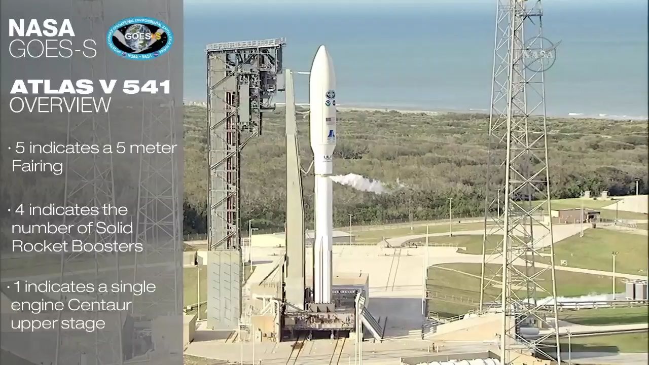
Screenshot from NASA/ULA Webcast of the launch of GOES-S. Springtime in Florida - No leaves
Mission Rundown: ULA - Atlas V 541 - GOES-S
Written: December 2, 2022
Weather mean Sun, Rain and Shitstorms
United Launch Alliance’s Atlas V rocket has deployed an advanced weather satellite for the US National Oceanic and Atmospheric Administration Thursday. The mission to deploy the GOES-S satellite began with liftoff from the Cape Canaveral Air Force Station at the opening of a two-hour window at 17:02 Eastern Time (22:02 UTC).
GOES-S is the second of four satellites making up the fifth generation of the Geostationary Operational Environmental Satellite (GOES) program, a series of spacecraft that the National Oceanic and Atmospheric Administration (NOAA) uses to provide continuous monitoring of weather conditions in the United States and across the western hemisphere. At any time, the GOES constellation consists of two operational satellites in geostationary orbit, plus a number of spares.
The two operational satellites are stationed at 75 and 137 degrees West – places or slots designated GOES-EAST and GOES-WEST respectively.
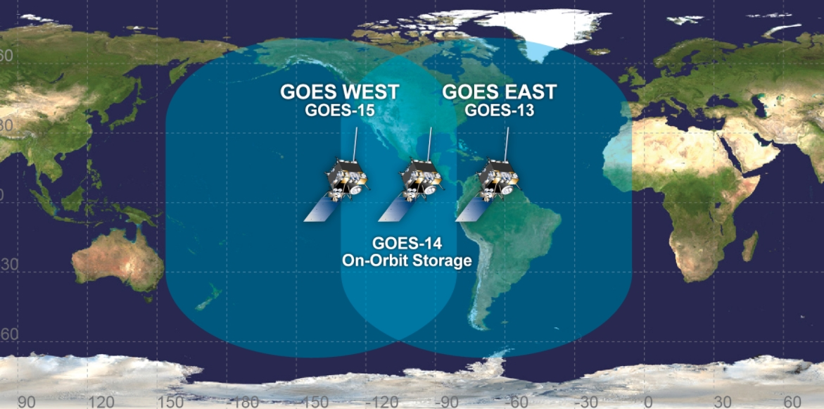
GOES satellites with area of observation. GOES-S will replace GOES-15 as GOES-17 - via NOAA
The satellite occupying GOES-EAST is responsible for monitoring the eastern United States, the Atlantic Ocean, Caribbean and the Gulf of Mexico. GOES-WEST covers the western regions of the continental United States, Alaska and Hawaii and the Pacific Ocean. GOES-S, which will be renamed GOES 17 after it reaches geostationary orbit, is expected to replace the eight-year-old GOES 15 in the GOES-WEST slot towards the end of this year.
The GOES-S Payload
The GOES-R-class satellites are being built by Lockheed Martin. They are based on the A2100A satellite bus and each has a mass at launch of 5,192 kilograms (11,466 lb) with dimensions of 6.1 by 5.6 by 3.9 meters (20 by 18 by 13 feet). The satellites are designed to operate in orbit for fifteen years: consisting of five years’ on-orbit storage and ten years of weather monitoring. GOES-S is equipped with a LEROS-1C liquid apogee motor, which will be used following launch to raise the satellite into its final geostationary orbit. Electrical power is generated through a single five-panel solar array that will provide over four kilowatts for the satellite’s systems and instruments.
The core propulsion module forms the main central structure of the satellite and carries the propellant and thrusters needed to maneuver the spacecraft after it is separated from the launch vehicle. Solar panels, batteries, memory data banks, avionics and receivers with high gain antennas also are a major part of the main central structure.
It’s hard to believe that more than 70 electronics boxes mounted within the system module provide the functionality to operate the spacecraft and its six instruments.
GOES-S carries a suite of six scientific instruments and is also equipped with a data relay payload. The satellite’s main instrument is the Advanced Baseline Imager (ABI), which is mounted on its nadir – Earth-facing – side. ABI can produce images of the Earth in sixteen different spectral bands, covering visible light through to infrared. At a visible-light wavelength of 0.64 nanometres, ABI can achieve an imaging resolution of 500 meters (547 yards), while in the infrared it can image at a resolution of up to 2,000 meters (2,187 yards). This is twice the resolution provided by the imager aboard the GOES 15 satellite that GOES-S will replace.
The imager can be operated in full-disc, regional and mesoscale modes. In normal operation it will produce four full-disc images of the whole visible face of the Earth, twelve regional scans of the United States and 120 mesoscale images – each covering an area of one million square kilometers (390,000 square miles) – per hour. An alternative mode of operation allows the satellite to produce full-disc images exclusively, outputting a new image every five minutes.
A second Earth-facing payload, the Geostationary Lightning Mapper (GLM), will monitor the Earth for sudden visual events in order to help build a map of lightning activity. GLM was first flown aboard GOES 16, and the instrument aboard GOES-S will help to provide similar data for the western United States to that now available for the eastern states. By monitoring lightning, GOES satellites will help forecasters predict storms, provide warnings of severe weather, and determine whether ongoing storms are increasing or decreasing in strength. In the west, this data will also help firefighters to identify lightning strikes that may cause wildfires.
As well as monitoring the Earth’s weather, GOES-S will perform solar observations to help forecast space weather. Its Solar Ultraviolet Imager (SUVI) and Extreme Ultraviolet and X-Ray Irradiance Sensors (EXIS) are mounted on the sun-tracking arm that connects the satellite’s solar array to its body. This affords them a near-continuous view of the sun as the solar array tracks it across the sky.
SUVI operates in the extreme ultraviolet, capturing full-disc images of the sun that can be used to monitor eruptions, solar flares and changes on the solar surface. EXIS, which consists of the Extreme Ultraviolet Sensor (EUVS) and X-Ray Sensor (XRS), monitors specific spectral bands in light coming from the Sun. EUVS looks for variations in emission lines from helium, hydrogen and magnesium that can be used to characterize emissions from different parts of the sun and to model its ultraviolet spectrum as a whole. XRS helps to characterize solar flares and measure the sun’s irradiance.
The Space Environment In-Situ Suite (SEISS) will be used to take readings of the immediate space environment in which GOES-S will operate. it consists of five sensors: the Energetic Heavy Ion Sensor (EHIS), two Magnetic Particle Sensors (MPS-Hi and MPS-Lo), two Solar and Galactic Proton Sensors (SGPS) and a boom-mounted magnetometer.
EHIS will be used to measure the flux of heavier ions trapped in Earth’s magnetosphere or incoming from extraterrestrial sources. The Magnetic Particle Sensors will measure the flux of protons and electrons: MPS-Hi will monitor higher-energy particles and MPS-Lo will measure lower-energy particles. The two identical SGPS sensors will measure protons incident from the sun and from outside the solar system.
GOES-S will also be used as a relay satellite through its Unique Payload Services (UPS) suite which will support four communications applications. GOES Rebroadcast (GRB) allows compatible receivers to download the latest observational data directly from the satellite, without waiting for the NOAA to publish it. The Data Collection System (DCS) is used to relay data from remote unmanned research stations back to the NOAA. The Emergency Managers Weather Information Network (EMWIN) is used to provide forecasts and other data to support emergency response and management.
Through their communications payloads, the GOES spacecraft also support the international COSPAS-SARSAT search and rescue program. GOES satellites can pick up distress signals from ships, aircraft and personal locator beacons (PLBs) and relay them to a control center from where rescue operations can be coordinated.
The Atlas 541 Launch
Atlas V, which was originally developed by Lockheed Martin, is a two-stage rocket. First flown in August 2002, Atlas has completed seventy-five missions prior to Thursday’s launch which is launch number 76.
Atlas consists of two liquid-fuelled stages, with optional solid rocket motors attached to the first stage which can provide additional thrust during the early stages of flight. The rocket can fly in several different configurations, varying the number of solid rocket motors between zero and five, using a single or dual-engine second stage and a payload fairing with a diameter of four or five meters (13 or 16 feet). This allows it to cater to different mission requirements in terms of payload mass, volume and target orbit.
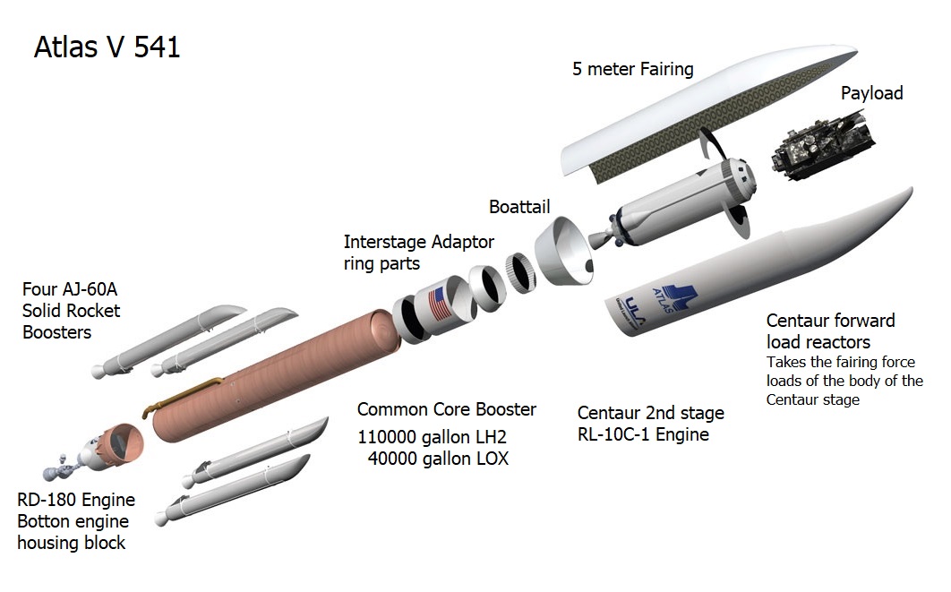
Graphic of the Atlas 541 split apart in its major parts. The fairing is actually in four parts. Stacked together between the Centaur top avionics and the payload adaptor fitting below GOES-S.
For Thursday’s launch, Atlas flew in the 541 configuration, which uses a five-meter payload fairing, four solid rocket motors and a single-engine Centaur upper stage. The five-meter fairing, which is built by Swiss firm RUAG, encloses both the GOES-S satellite and the Centaur stage, protecting them from the atmosphere as Atlas climbs towards space. The Atlas V that performed Thursday’s launch has tail number AV-077. It launched from Space Launch Complex 41 (SLC-41) at the Cape Canaveral Air Force Station.
During Thursday’s countdown, Atlas was fuelled, checked-out and made ready to launch. The rocket’s first stage, or Common Core Booster (CCB), is powered by a single RD-180 engine which ignites 2.7 seconds before the countdown reaches zero. Ignition of the four Aerojet AJ-60A solid rocket motors occurred at liftoff, which took place at about T+1.1 seconds. The vehicle began a series of pitch and yaw maneuvers 4.1 seconds later, placing it onto the planned course for its ascent to orbit.
Under the power of its main engine and four solid rocket boosters, AV-077 climbed quickly away from Cape Canaveral, reaching Mach 1 – the speed of sound – 35.2 seconds after liftoff. The rocket passed through Max-Q, the area of maximum dynamic pressure, 47.1 seconds into flight.
The solid rocket motors burned out around 98 seconds into the mission. Their spent casings were jettisoned at the 110.3-second mark in the flight. With the AJ-60s gone, the CCB’s RD-180 engine continued to burn as AV-077 climbed out of the atmosphere. The RD-180 burns RP-1 kerosene propellant, oxidized by liquid oxygen.
Once Atlas reached space, the payload fairing was no longer needed to protect its payload and was discarded to reduce the vehicle’s weight. The fairing separated about three minutes, 29.9 seconds after launch. Shortly afterward the Forward Load Reactor (FLR), which attaches to the rocket’s upper stage to help increase the rigidity of the fairing, was also separate.
The Atlas booster exhausted its fuel and ended its burn four minutes and 21.9 seconds after lifting off. This event, designated Booster Engine Cutoff (BECO), was followed by stage separation six seconds later. Atlas’ second stage, a single-engine Centaur (SEC), ignited its RL10C-1 engine ten seconds after separation. Centaur, which traces its heritage back to the early 1960s, is a cryogenically-fuelled stage burning liquid hydrogen propellant and liquid oxygen. During Thursday’s launch, it made three burns.
Centaur’s initial burn lasted seven minutes and 33.8 seconds, placing itself into a parking orbit. Restarting after a ten-minute, 26.7-second coast as it crosses the equator, the stage fired for a further five minutes and 30.9 seconds to reach geosynchronous transfer orbit. The third and final burn lasted 94.4 seconds, beginning after an almost-three-hour coast phase at three hours, 28 minutes and 7.9 seconds mission elapsed time. This raised the perigee and lower the inclination of the rocket’s orbit, reducing the amount of fuel that GOES-S will need to expend raising itself into geostationary orbit.
GOES-S separated from AV-077 about two minutes and 49 seconds after the third burn ends. The target orbit for spacecraft separation is 8,215.47 by 35,286.67 kilometers (5,104.86 by 21,926.12 miles, 4,436.00 by 19,053.28 nautical miles) at an inclination of 9.52 degrees and with an argument of perigee of 179.69 degrees. About 26 minutes and 20 seconds after deploying GOES-S, Centaur began a blowdown to secure itself, before the expected end of mission, at four hours, 32 minutes and 11.3 seconds after liftoff – twenty seconds shy of an hour after spacecraft separation.
Thursday’s launch was the second of the year for the Atlas V rocket, following January’s successful deployment of the SBIRS GEO-4 missile detection satellite.
Ingen kommentarer:
Send en kommentar