
Screenshot from NASA/ULA Webcast of ICESat-2. You got me up now. Light what candle?
Mission Rundown: ULA - Delta II - ICESat-2
Written: September 24, 2021 - Edit: December 1, 2022
60 years of service for USA
The ICESat-2 spacecraft was launched on 15 September 2018 at 06:02 PDT - 13:02 UTC from VAFB, CA Space Launch Complex -2W on a Delta-II 7420-10 vehicle configuration.
After twenty-nine years of reliable service, United Launch Alliance’s veteran Delta II rocket made its final flight Saturday with the deployment of the ICESat-2 climate research satellite for NASA. Delta lifted off from Vandenberg Air Force Base at 06:02 Pacific Daylight Time, beginning a mission that also closed the final chapter in the 60-year-long history of the Thor missile, from which Delta II’s first stage evolved.
The Delta II rocket rocking chair
Delta II made ULA’s first launch on 16 December 2006, deploying the USA-193 – or NROL-21 – satellite for the National Reconnaissance Office. Although Delta performed perfectly, the payload failed immediately after separating from the rocket.
In 2008 it was shot down by a US Navy destroyer using a RIM-161 Standard Missile 3 (SM-3), ostensibly to prevent the satellite causing any damage when it reentered the atmosphere. That’s at least 160 kilometers above Earth's surface. Impressive.
Okay. Mikey. Take aim and hit that target up yonder.
With Saturday’s mission, ULA has launched its last and 30th of the 155 Delta II rockets.
ICESat-2 will operate in a near-circular sun-synchronous low Earth orbit, at an altitude of 500 kilometers (310 miles, 270 nautical miles), inclined at 92 degrees to the Equator. This orbit will take it over Earth’s polar regions, allowing it to see the whole of the globe between 88 degrees North and 88 degrees South.
A two-stage Delta II rocket, flying in the 7420-10C configuration, provided ICESat-2 and the ELaNa 18 CubeSats with their ride into orbit. The 7420-10C configuration consists of an Extra Extended Long Tank Thor first stage augmented at liftoff by four GEM-40 solid rocket motors and a Delta-K second stage. ICESat-2 is encapsulated within a 10-foot (3-meter) wide composite payload fairing at the nose of the rocket.
Delta II’s first stage engine burns RP-1 propellant – kerosene – and liquid oxygen. The Delta-K consumes storable propellant: Aerozine 50 – a mixture of equal parts hydrazine and unsymmetrical dimethylhydrazine – which is oxidized by dinitrogen tetroxide.
The Delta II rocket stands 40.2 meters - 132 feet tall and weighs about 162 386 kilograms - 358 000 pounds fully fueled. It will launch on nearly 2,89 Mega Newtons - 650 000 pounds of thrust from the RS-27A main engine and four side-mounted solid rocket motors.
The Delta II family used a four-digit system to generate its technical names.
The first digit was either 6 or 7, denoting the 6000- or 7000-series Delta rocket.
The second digit indicated the number of boosters. Most Delta II rockets flew with 9 boosters, but some flew with 3 or 4.
The third digit was always 2, denoting a second stage with an Aerojet AJ10 engine. Only Deltas prior to the 6000-series used a different engine, the TR-201.
The fourth digit denoted the third stage. 0 denoted no third stage, 5 indicated a Payload Assist Module (PAM) stage, the Star 48B solid motor, 6 indicated the Star 37FM motor.
An H following the four digits denoted that the vehicle used the larger Delta III GEM-46 boosters. The Heavy variant could be launched only from Cape Canaveral (Vandenberg's pad wasn't modified to handle the larger SRBs), and was retired with the closure of that launch site in 2011.
Numbers and letters following those indicate the type of fairing. -9.5 means that the vehicle had a 9.5 ft (2.9 m) diameter fairing, -10 means a 10 ft (3.0 m) diameter fairing, and -10L indicates a lengthened 10 ft (3.0 m) diameter fairing.
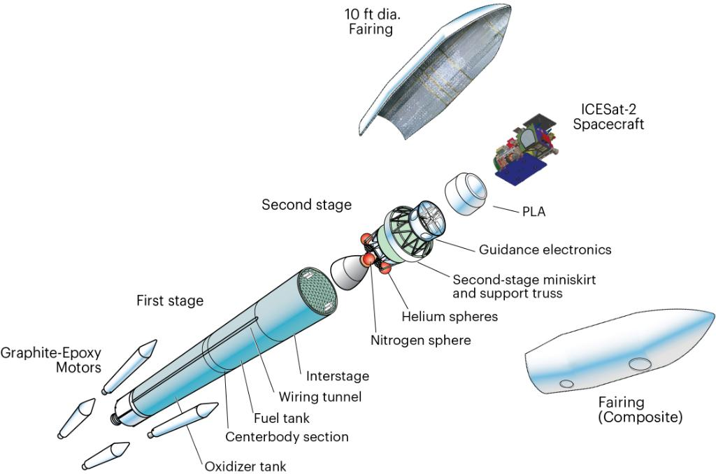
Graphic of Delta II seen split in its major parts. Interstage and fairings hides most of 2nd stage
For example, This Delta II 7420-10 used an RS-27A engine, four GEM-40 boosters, no third stage, and a lengthened 10 ft (3.0 m) diameter, the C means a carbon composite fairing.

Photo of a Delta II fairing being unwrapped. Do you by any chance want to buy an empty boat hull?
Delta II rockets have launched satellites that continue to play a role in everyday life – such as most of the US Air Force’s current Global Positioning System (GPS) as well as seventeen commercial geostationary communications satellites, much of the first-generation Iridium and Globalstar communications networks and weather satellites that provide accurate meteorological data to NOAA.
Delta II has also made a huge contribution to science, deploying missions to study the Earth, visit the planets and observe the cosmos.
Delta II rockets were used to send eight missions to Mars: Mars Global Surveyor, Mars Pathfinder, Mars Climate Orbiter, Mars Polar Lander, Mars Odyssey, the two Mars Exploration Rovers: Spirit and Opportunity, and Phoenix.
Delta II also deployed the NEAR, Deep Space 1, Stardust, CONTOUR, Deep Impact and Dawn missions to explore asteroids and comets – with Dawn also visiting the dwarf planet Ceres – the MESSENGER probe to Mercury and the GRAIL probes – Ebb and Flow – to study the Moon’s gravitational field.
Other significant missions that started atop a Delta II rocket included the Fermi, Kepler, Spitzer, Swift and WISE space telescopes and the Genesis spacecraft that returned a sample of solar wind to Earth.
The Science Payload
ICESat-2 is a NASA follow-up mission to ICESat with the goal to continue measuring and monitoring the impacts of the changing environment. The ICESat-2 observatory contains a single instrument, an improved laser altimeter called ATLAS (Advanced Topographic Laser Altimeter System). ATLAS is designed to measure ice-sheet topography, sea ice freeboard as well as cloud and atmospheric properties and global vegetation. The requirements call for a 5-year operational mission with a goal of 7 years.
ICESat-2, with high altimetric fidelity, will provide high-quality topographic measurements that allow estimates of ice sheet volume change. High-accuracy altimetry will also prove valuable for making long-sought repeat estimates of sea ice freeboard and hence sea ice thickness change, which is used to estimate the flux of low-salinity ice out of the Arctic basin into the marginal seas.
Altimetry is the best (and perhaps only) technique for change studies, because sea ice areas and extends have been well observed from space since the 1970s and significant trends have been shown, but there is no such record for sea ice thickness.
The instrument will use a micro-pulse multi-beam photon-counting approach. Science and ancillary data will be collected, stored on-board and subsequently downlinked to ground stations via an X-band communications link.
This link will also include stored housekeeping telemetry. The observatory will also receive and store/execute commands and transmit real-time housekeeping telemetry via an S-band link to the NASA Ground Network.
ICESat-2 uses the LEOStar-3 platform (for NASA's Landsat-8, the GeoEye-1 Earth imaging satellite) and is being built and integrated at the Gilbert, AZ, location of Orbital ATK.
As for propulsion it uses blowdown hydrazine, four main 22 N thrusters and eight station keeping 4.5 N thrusters, there is only a 158 kg tank capacity giving it a 3-5 year lifespan and with a frugal 7 service length flying on vapors.
NASA/GSFC engineers fitted a small telescope in the ICESat-2. In a Goddard cleanroom, teams are working in parallel on two sections of ATLAS: the box structure, which holds electronics that control the instrument, and the optical bench, which supports the instrument's lasers, mirrors, and the 0.8 m, 20.8 kg beryllium telescope that collects light.
Each ATLAS laser pulse contains more than 200 trillion photons, but only a dozen or so return to the telescope, where they're sent via optical fibers to the instrument's detectors. To catch those few photons, the telescope and its associated equipment, called the RTA (Receiver Telescope Assembly), need to align perfectly to the laser.
In addition to ICESat-2, this mission includes ELaNa 18’s four cubesats that will launch from dispensers mounted to the Delta II’s second stage.
The secondary payloads on IceSat-2 are:
• ELFIN (Electron Losses and Fields Investigation), a pair of 3U CubeSats of UCLA (University of California Los Angeles).
• SurfSat (Surface charging Satellite), a 2U CubeSat mission developed at the UCF (University of Central Florida), Orlando, FL.
• CP-7 (CalPoly-7) or DAVE (Damping And Vibrations Experiment), a 1U CubeSat, a collaboration of Northrop Grumman Aerospace Systems and CalPoly.
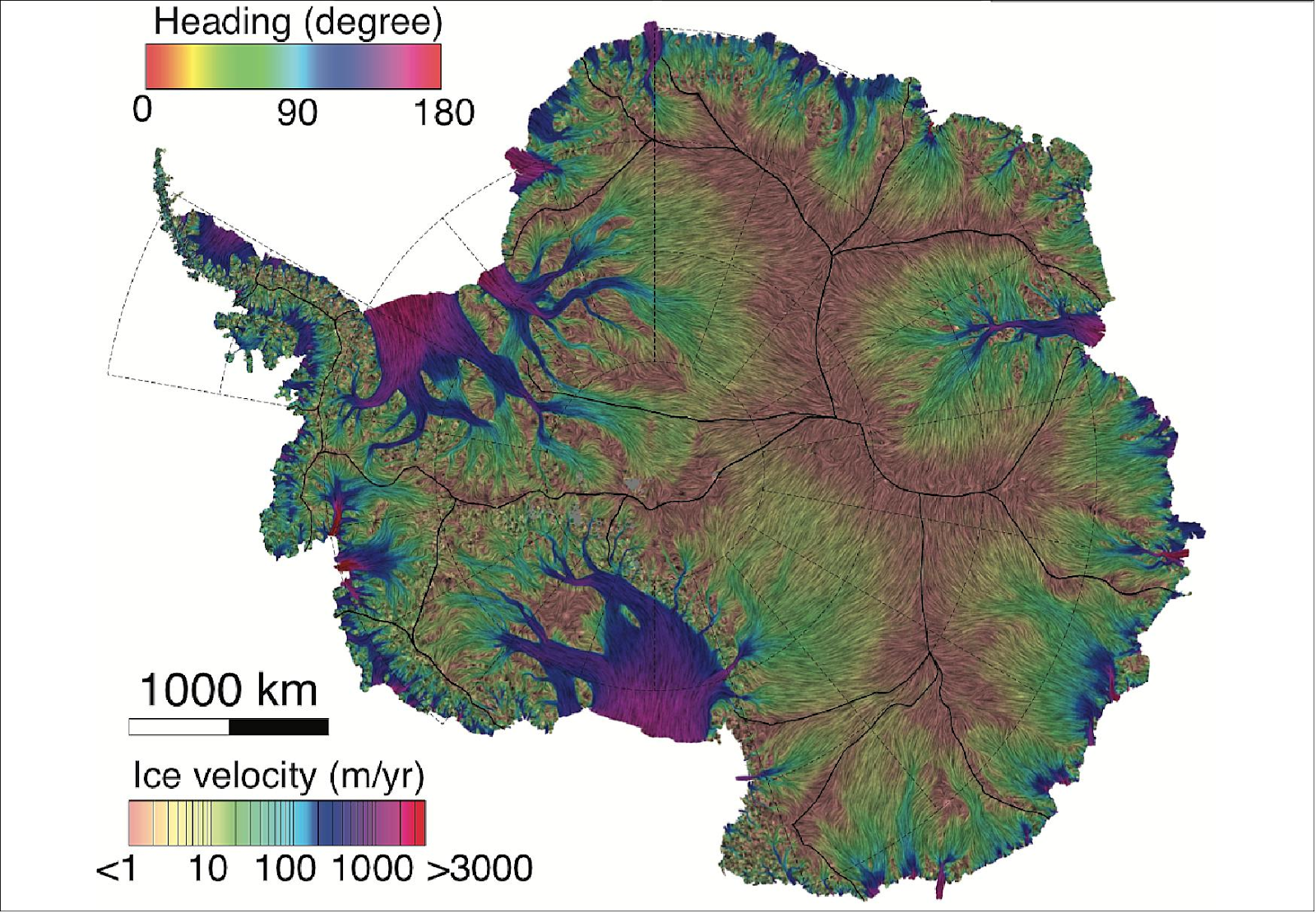
This new NASA/UC Irvine map of ice velocity in Antarctica is 10 times more accurate than any previous map and shows flows over 80% of the continent, where older maps showed about 20%. Colored lines indicate direction of flow; background colors show speed (image credit: UCI/Jeremie Mouginot) source
ICESat-2 will provide scientists with height measurements that create a global portrait of Earth’s third dimension, gathering data that can precisely track changes of terrain including glaciers, sea ice, forests and more.
The single instrument on ICESat-2 is ATLAS, the Advanced Topographic Laser Altimeter System, will measure melting ice sheets and investigate how this affects sea level rise, investigate changes in the mass of ice sheets and glaciers, estimate and study sea ice thickness, and measure the height of vegetation in forests and other ecosystems worldwide.
Scientists are using ICESat-2 to measure all kinds of ecosystems far beyond the polar regions, including sea grass growth in shallow coastal waters, forest growth in Africa and even the areas where Penguins congregate. Maps of the shallow waters around coral reefs worldwide are being produced using data from ICESat-2.


Ingen kommentarer:
Send en kommentar